


SkyWalking - The GPS Logger app for iPhone and iPad
Developer: DEEP KICK.com
First release : 25 Mar 2016
App size: 28.21 Mb
---------------------------
[ Overview of SkyWalking ]
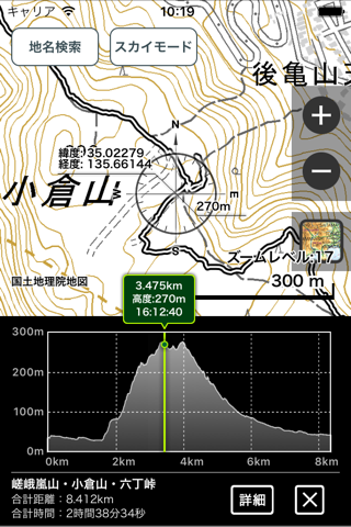
"SkyWalking is a GPS logging application developed for outdoor activities in harsh environments such as mountain climbing and ultra-marathons, where you have to travel for a long time in mountainous or desert areas without internet access. As a GPS logger, it can record your activities while tracing them in real time on a cached map, and export them to a GPX file to be shared with external services. It is also an application that allows you to enjoy the GPS logging in situations other than mountaineering, such as normal outings and travel. This app has been developed since its release in 2015 with the goal of "making GPS logging and GPS location information easily available to all iPhone users". By installing this app, your iPhone will become a highly functional GPS gear that can accurately determine your current location and route.
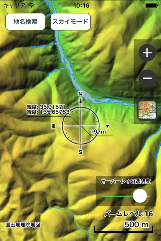
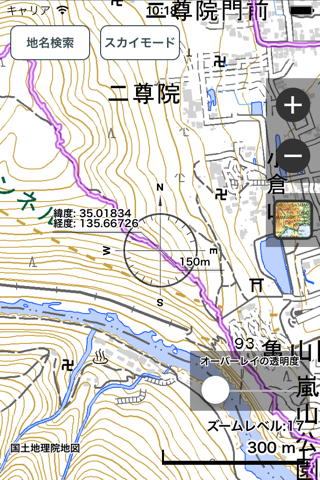
You can use the high performance Apple Map in urban areas where you can connect to the internet, and use the cached OpenStreetMap and OpenCycleMap as offline maps in mountainous areas where you cannot connect to the internet. In SkyWalking, when OpenStreetMap or OpenCycleMap is selected, the displayed map is permanently stored as a cache of tile data inside the application, and thereafter the cached data is used without depending on the Internet. Once the data is displayed at the required zoom level, it can be used as it is unless you explicitly delete the cached data, so it can be used as an offline map. For details on how to use, please refer to the SkyWalking official website or How to Use in the app. Cached areas can greatly reduce the risk of getting lost by displaying your current location, elevation, direction, planned route, destination, etc. on the map, even in environments without Internet access.
By exporting recorded GPS logs to general-purpose file formats such as GPX and CSV, you can use them in conjunction with other map applications and location information sharing services, or import GPX files from outside into SkyWalking and display them as reference routes on the map. SkyWalking also has an editing function for GPX files. SkyWalking is ideal for mountaineering, trail running, climbing, cycling, backcountry skiing, snowboarding, and other outdoor activities, as well as for driving, traveling, and topographical surveys.
Enjoy GPS Logging with SkyWalking!
---------------------------
[ Supported devices ]
iPhone or iPad with iOS 12.0 or later. iPhone 7 or later is recommended.
---------------------------
[ Notes and Disclaimer ]
* SkyWalking is being developed with the aim of creating a GPS logging application that is easier to use, but there is no possibility of serious consequences due to usage, bugs in the application, or malfunction. Please use it at your own risk.
* During GPS log acquisition, GPS continues to operate even when the application is in the background, which consumes battery power. Please be careful not to run out of battery during outdoor activities by carrying a mobile battery for recharging.
* If you are considering using the app in an area where you cannot connect to a network, we recommend that you verify the operation of the app well in advance and gain knowledge about the app and mountain climbing before using it. Use of the app in dangerous areas such as mountainous areas, or in emergency situations such as disasters, may result in serious consequences. Please use the product at your own risk.